


Phantom 4 RTK SE Combo
Phantom 4 RTK SE Combo
SKU:CB.202204020287
Couldn't load pickup availability
One of the fastest growing applications in the commercial drone industry has been surveying and mapping, where drones have been used to significantly improve efficiency and safety. The new addition to DJI's Phantom 4 Series, the Phantom 4 RTK was designed by looking at the requirements of the drone mapping and surveying market and building exactly what they wished for – a compact drone solution with a high resolution camera and the ability to capture centimeter-accurate RTK data.
Next Generation Mapping
With the brand-new Phantom 4 RTK, DJI has created a system that meets the demanding requirements of the drone mapping and surveying market, in one compact and easy-to-use solution with a high-resolution camera and the ability to capture centimetre-accurate RTK data while requiring fewer ground control points.

1cm+1ppm
RTK Horizontal Positioning Accuracy

1.5cm+1ppm
RTK Vertical Positioning Accuracy

(*When flying at 100m height, 2.7cm GSD,sunny)
Centimetre Level Positioning System
With a new RTK Module that is integrated into the Phantom 4 RTK, real-time centimetre-level positioning data is improved for absolute accuracy on image metadata. Below the RTK receiver is a redundant GNSS module installed to maintain flight stability in regions with poor signals such as dense cities. With the combination of both modules, the Phantom 4 RTK is able to enhance flight safety while ensuring that the most precise data possible is captured for complex mapping, surveying, and inspection workflows.
Users can fit the Phantom 4 RTK to any workflow with the ability to connect the positioning system to the D-RTK 2 Mobile Station, Network Transport of RTCM via Internet Protocol (NTRIP) using a 4G dongle or WiFi hotspot, or store the satellite observation data to be used for Post Processed Kinematics (PPK).

Gather Accurate Data with TimeSync
To unlock the full power of the Phantom 4 RTK's positioning modules, the new TimeSync system was created to continually align the flight controller, RTK module and camera. TimeSync also ensures that each photo uses the most accurate metadata, and fixes the positioning data to the centre of the CMOS sensor to optimize results from photogrammetric methods to allow the image to achieve centimetre-level positioning data.

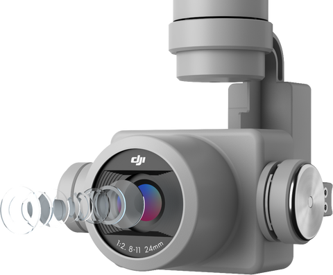
Precise Imaging System
Operators are able to capture the best image data possible thanks to the Phantom 4 Pro's camera, featuring a 1-inch, 20 -megapixel sensor. The camera's mechanical shutter also makes mapping missions and regular data capture seamless as the Phantom 4 RTK can move while taking pictures without the risk of any rolling shutter blur. With the high resolution of its camera, the Phantom 4 RTK can achieve a Ground Sample Distance (GSD) of 2.74 cm at 100 metres flight altitude. To ensure the Phantom 4 RTK offers unparalleled accuracy, each camera lens goes through a rigorous calibration process where radial and tangential lens distortions are measured carefully. The distortion parameters are then gathered and saved into each image's metadata, allowing post-processing software to uniquely adjust for every user.
Purpose-Built Flight Planning Application
With the new GS TRK app pilots are able to intelligently control their Phantom 4 RTK with two different planning modes - Photogrammetry and Waypoint Flight, alongside a more traditional flight mode. The planning modes enable pilots to select the drone's flight path while adjusting overlap rate, altitude. camera parameters, speed, and more, offering an automated mapping and/or inspection workflow.
The GS RTK App has been created with its users in mind to improve specific mapping and inspection workflows. The app has implemented direct loading of KML area files for in-office flight planning, a brand new shutter priority mode to keep exposure consistent across all photos, as well as a strong wind alarm to warn pilots of any adverse or extreme conditions.

Mobile SDK Supported
The Phantom 4 RTK is compatible with the DJI Mobile SDK, which opens up its functions to customization and automation through a mobile device.
Improved OcuSync Transmission System
Users can enjoy stable and reliable HD image and video transmission at distances of up to 7 kilometres, which is perfect for mapping larger sites.

Seamless Compatibility with D-RTK 2 Mobile Station (not included in this package)
Operators can support your Phantom 4 RTK missions with the D-RTK 2 Mobile Station - providing users with real-time differential data to the drone and forming an accurate surveying solution. The OcuSync 2 Transmission system and the Mobile Station's rugged design ensures that operators can gain centimetre-level accurate data with their Phantom 4 RTK in any condition.
Start Mapping Today!
With an easy method to collect RTK Data (RTK Network or D-RTK 2 Mobile Station) and a built-in flight planning app (GS RTK), pilots have a full mapping, surveying and inspection workflow solution that is easy-to-use, right out of the box.

In the Box
- Phantom 4 RTK Drone
- Phantom 4 RTK Aircraft
- Remote Controller (with screen)
- Propellers Pair (x4)
- Phantom 4 Pro Intelligent Flight Batteries (x2)
- AC Power Cable
- Remote Controller Intelligent Battery
- AC Power Adapter (100W)
- Gimbal Clamp
- 16G Micro SD Card
- Carrying Case
- Micro USB Cable
- USB-C Cable
- USB-C OTG Cable
- Phillips Screw (x2)
- Enterprise Care Basic (activation code to be provided upon purchase)
Note: D-RTK 2 High Precision GNSS Mobile Station and D-RTK 2 Base Station Tripod are not included in this package.


